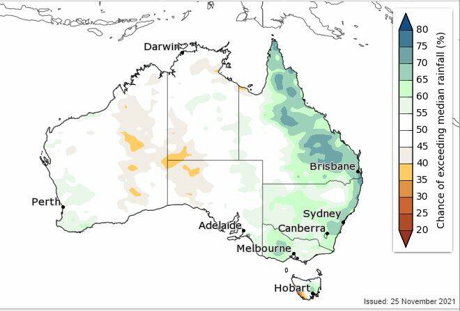
Eastern Australia has been marked for a "wetter than average summer" in the Bureau of Meteorology's latest Summer Climate and Water Outlook for 2021 to 2022.
Subscribe now for unlimited access.
or signup to continue reading
The Bureau's Head of Operational Climate Services, Dr Andrew Watkins, presented the outlook on Thursday after a La Nina weather pattern was declared earlier this week.
"Summer is likely to see above average rainfall across eastern Australia, warmer than average days and nights across most of the country, high stream flows at most locations with an increased risk of widespread flooding and grassfire risk is raised in areas of NSW and WA," Dr Watkins said.
The BOM has also warned of the increased likelihood of damaging tropical cyclones, heavy rainfall and widespread flooding.
Further to the west, where the influence of the La Nina are not so pronounced, there are no strong swings to either wetter or drier conditions in South Australia, while parts of Western Australia are likely to see average to slightly above average rainfall.
IN OTHER NEWS:

Dr Watkins said La Nina was just one of several climate drivers likely to create continuing wet conditions for parts of eastern Australia this summer.
"The big driver looking at the months ahead is La Nina, which is now established in the Pacific Ocean for the second year in a row. La Nina describes a pattern of ocean temperatures that sees warmer waters in the western Pacific, which in turn drives increased atmospheric moisture and rainfall, including heavy rainfall, over Australia," Dr Watkins said.
READ MORE:
He said this pattern is likely to continue through until at least the end of January.
Other climate drivers have also played a role in the BOM outlook.
"Over winter and spring we saw a negative Indian Ocean Dipole, a pattern of ocean temperature patterns in the oceans to our west that was favourable to rainfall over Australia, and a dominant influence on our climate," he said.
"While this event is approaching its end, warmer waters to the north-west of Australia may persist, and continue to increase the chance of rainfall," Dr Watkins said.
He said the La Nina could lead to unseasonably high rainfall in the normally winter-dominant rainfall areas of the south.
"December is likely to see our typical summer weather systems pushed further south than normal, meaning more humid air coming off the Tasman Sea, and into NSW and eastern Victoria."
The BOM's summer outlook comes amid heavy rainfall and widespread flooding in eastern parts of country, which has also been attributed to La Nina.
Our journalists work hard to provide local, up-to-date news to the community. This is how you can continue to access our trusted content:
- Bookmark https://www.bordermail.com.au/
- Make sure you are signed up for our breaking and regular headlines newsletters
- Follow us on Twitter: @bordermail
- Follow us on Instagram @bordermail
- Follow us on Google News.


